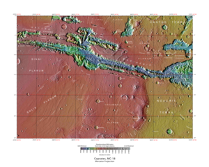
Coprates quadrangle
The Coprates quadrangle is one of a series of 30 quadrangle maps of Mars used by the United States Geological Survey (USGS) Astrogeology Research Program . The Coprates quadrangle is also referred to as MC-18 (Mars Chart-18). [1] The Coprates quadrangle contains parts of many of the old classical regions of Mars: Sinai Planum , Solis Planum , Thaumasia Planum , Lunae Planum , Noachis Terra , and Xanthe Terra .
Page Revisions
| Year | Metadata | Sections | Top Words | First Paragraph |
| 2018 |
181919 characters 16 sections 86 paragraphs 76 images 310 internal links 38 external links |
2. Valles Marineris canyon system 3. Interior layered deposits and sulfate 5. Herbes Chasma and hydrated deposits |
chasma 0.541 hirise 0.270 layers 0.254 hiwish 0.244 coprates 0.215 ius 0.182 marineris 0.181 valles 0.172 program 0.137 louros 0.133 canyon 0.125 juventae 0.116 deposits 0.115 candor 0.112 wall 0.099 |
The Coprates quadrangle is one of a series of 30 quadrangle maps of Mars used by the United States Geological Survey (USGS) Astrogeology Research Program . The Coprates quadrangle is also referred to as MC-18 (Mars Chart-18). [1] The Coprates quadrangle contains parts of many of the old classical regions of Mars: Sinai Planum , Solis Planum , Thaumasia Planum , Lunae Planum , Noachis Terra , and Xanthe Terra . |
| 2017 |
177298 characters 16 sections 82 paragraphs 71 images 310 internal links 36 external links |
2. Valles Marineris canyon system 3. Interior layered deposits and sulfate 5. Herbes Chasma and hydrated deposits |
chasma 0.545 hirise 0.252 layers 0.250 coprates 0.222 hiwish 0.212 ius 0.188 marineris 0.186 valles 0.177 louros 0.137 canyon 0.128 program 0.120 juventae 0.119 deposits 0.118 candor 0.115 wall 0.102 |
The Coprates quadrangle is one of a series of 30 quadrangle maps of Mars used by the United States Geological Survey (USGS) Astrogeology Research Program . The Coprates quadrangle is also referred to as MC-18 (Mars Chart-18). [1] The Coprates quadrangle contains parts of many of the old classical regions of Mars: Sinai Planum , Solis Planum , Thaumasia Planum , Lunae Planum , Noachis Terra , and Xanthe Terra . |
| 2016 |
157424 characters 15 sections 67 paragraphs 59 images 305 internal links 26 external links |
2. Valles Marineris canyon system 3. Interior layered deposits and sulfate 5. Herbes Chasma and hydrated deposits |
chasma 0.596 layers 0.234 coprates 0.233 hirise 0.224 ius 0.192 marineris 0.183 hiwish 0.149 canyon 0.143 juventae 0.133 deposits 0.132 valles 0.131 candor 0.128 melas 0.108 channels 0.099 inverted 0.097 |
The Coprates quadrangle is one of a series of 30 quadrangle maps of Mars used by the United States Geological Survey (USGS) Astrogeology Research Program . The Coprates quadrangle is also referred to as MC-18 (Mars Chart-18). [1] The Coprates quadrangle contains parts of many of the old classical regions of Mars: Sinai Planum , Solis Planum , Thaumasia Planum , Lunae Planum , Noachis Terra , and Xanthe Terra . |
| 2015 |
140864 characters 12 sections 58 paragraphs 49 images 274 internal links 24 external links |
1. Valles Marineris canyon system 2. Interior layered deposits and sulfate 4. Herbes Chasma and hydrated deposits |
chasma 0.589 coprates 0.225 layers 0.217 hirise 0.203 marineris 0.202 canyon 0.158 juventae 0.147 deposits 0.146 valles 0.145 candor 0.141 melas 0.119 ius 0.115 channels 0.109 inverted 0.107 wall 0.106 |
The Coprates quadrangle is one of a series of 30 quadrangle maps of Mars used by the United States Geological Survey (USGS) Astrogeology Research Program . The Coprates quadrangle is also referred to as MC-18 (Mars Chart-18). [1] The Coprates quadrangle contains parts of many of the old classical regions of Mars: Sinai Planum , Solis Planum , Thaumasia Planum , Lunae Planum , Noachis Terra , and Xanthe Terra . |
| 2014 |
128618 characters 11 sections 55 paragraphs 47 images 261 internal links 17 external links |
1. Valles Marineris canyon system 2. Interior layered deposits and sulfate 4. Herbes Chasma and hydrated deposits |
chasma 0.580 layers 0.228 coprates 0.226 marineris 0.219 hirise 0.213 canyon 0.171 valles 0.157 deposits 0.142 juventae 0.137 melas 0.129 channels 0.119 inverted 0.116 wall 0.115 click 0.115 candor 0.110 |
The Coprates quadrangle is one of a series of 30 quadrangle maps of Mars used by the United States Geological Survey (USGS) Astrogeology Research Program . The Coprates quadrangle is also referred to as MC-18 (Mars Chart-18). [1] |
| 2013 |
128633 characters 11 sections 55 paragraphs 49 images 261 internal links 17 external links |
1. Valles Marineris Canyon System 2. Interior layered deposits and sulfate 4. Herbes Chasma and hydrated deposits |
chasma 0.579 layers 0.227 coprates 0.226 marineris 0.219 hirise 0.213 valles 0.177 canyon 0.171 deposits 0.142 juventae 0.136 melas 0.129 channels 0.119 inverted 0.116 wall 0.115 click 0.114 candor 0.109 |
The Coprates quadrangle is one of a series of 30 quadrangle maps of Mars used by the United States Geological Survey (USGS) Astrogeology Research Program . The Coprates quadrangle is also referred to as MC-18 (Mars Chart-18). [1] |
| 2012 |
126163 characters 11 sections 55 paragraphs 47 images 260 internal links 17 external links |
1. Valles Marineris Canyon System 2. Interior layered deposits and sulfate 4. Herbes Chasma and hydrated deposits |
chasma 0.579 layers 0.227 coprates 0.226 marineris 0.219 hirise 0.213 valles 0.177 canyon 0.171 deposits 0.142 juventae 0.136 melas 0.129 channels 0.119 inverted 0.116 wall 0.115 click 0.114 candor 0.109 |
The Coprates quadrangle is one of a series of 30 quadrangle maps of Mars used by the United States Geological Survey (USGS) Astrogeology Research Program . The Coprates quadrangle is also referred to as MC-18 (Mars Chart-18). [1] |
| 2011 |
63841 characters 11 sections 44 paragraphs 35 images 116 internal links 11 external links |
1. Valles Marineris Canyon System 2. Interior layered deposits and sulfate 4. Herbes Chasma and hydrated deposits |
chasma 0.634 coprates 0.228 layers 0.224 hirise 0.165 canyon 0.156 juventae 0.150 deposits 0.147 melas 0.141 click 0.125 channels 0.121 candor 0.120 ius 0.114 marineris 0.112 themis 0.110 inverted 0.109 |
The Coprates quadrangle is one of a series of 30 quadrangle maps of Mars used by the United States Geological Survey (USGS) Astrogeology Research Program . The Coprates quadrangle is also referred to as MC-18 (Mars Chart-18). [1] |
| 2010 |
61440 characters 11 sections 44 paragraphs 35 images 113 internal links 10 external links |
1. Valles Marineris Canyon System 2. Interior layered deposits and sulfate 4. Herbes Chasma and hydrated deposits |
chasma 0.634 coprates 0.229 layers 0.224 hirise 0.165 canyon 0.156 juventae 0.150 deposits 0.147 melas 0.141 click 0.125 channels 0.121 candor 0.120 ius 0.114 marineris 0.112 themis 0.110 inverted 0.109 |
The Coprates quadrangle is one of a series of 30 quadrangle maps of Mars used by the United States Geological Survey (USGS) Astrogeology Research Program . The Coprates quadrangle is also referred to as MC-18 (Mars Chart-18). [1] |
| 2009 |
52064 characters 9 sections 40 paragraphs 32 images 102 internal links 7 external links |
1. Valles Marineris Canyon System 2. Interior layered deposits and sulfate |
chasma 0.638 layers 0.244 canyon 0.170 deposits 0.170 coprates 0.166 hirise 0.164 melas 0.154 juventae 0.136 marineris 0.122 click 0.121 themis 0.119 sapping 0.118 valles 0.105 candor 0.104 canyons 0.104 |
Valles Marineris is an exciting place which sports the largest canyon system in the solar system; this great canyon would go almost all the way across the United States. The name for the whole system of canyons is Valles Marineris. Starting at the west with Noctis Labyrinthus in the Phoenicis Lacus quadrangle , the canyon system ends in the Margaritifer Sinus quadrangle with Capri Chasma and Eos Chasma (in the south). The word Chasma has been designated by the International Astronomical Union to refer to an elongate, steep-sided depression. Valles Marineris was discovered by and named for the Mariner 9 mission. Moving east from Noctis Labyrinthus, the canyon splits into two troughs, Tithonium Chasma and Ius Chasma (in the south). In the middle of the system are the very wide valleys of Ophir Chasma (north), Candor Chasma , and Melas Chasma (south). Going farther to the east, one comes to Coprates Chasma. At the end of Coprates Chasma, the valley gets wider to form Capri Chasma in the north and Eos Chasma in the south. The walls of the canyons often contain many layers. The floors of some of the canyons contain large deposits of layered materials. Some researchers believe that the layers were formed when water once filled the canyons. The canyons are deep as well as long. In places they are 8-10 kilometers deep. Remember the Earth's Grand Canyon is only 1.6 kilometers deep. [1] |